Trails of Conifer
Fall is a great season to get outside and enjoy the beautiful state of Colorado. Here are 3 Conifer trails, for those who enjoy hiking and are looking to get outside this fall.
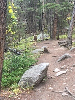
Meyers Ranch has wildlife like no other trail. Hikers on these trails may even see deer such as this one, on the trail.
Meyers Ranch is one of the most beautiful fall hikes. The trail is full of color; the grass is a vibrant green with floods of red and beige, and yellow aspens add diversity to the green pine trees. I saw the most wildlife, such as squirrels, birds, and even deer, on this trail. The trail, itself, is embedded in large rocks and has interesting formations, covered in moss and some forming small caves, along the side. Hikers may see a fair amount of dead trees along the trail but this makes the forest seem fuller and gives off a more natural aesthetic.
Meyers Ranch has a few loops. The longest loop is Old Ski Trail, which is ~2 hours of an easy-medium level hike (but there is a longer, small, off-trail path that leads to the top of the mountain, where hikers can see a view of Conifer and its mountains). The shortest of the trails is Lodgepool Loop, which is an easy 2.4 mile hike (roughly an hour), with plenty of places to stop. The in-between loop, Sunny Aspen Trail, is an easy-moderate, 3 mile hike (roughly 1.5 hours, round trip). These trails are 7800-8700 feet above sea level. They are all dog-friendly (leash required) and have a few picnic areas near the bottom of the trails.
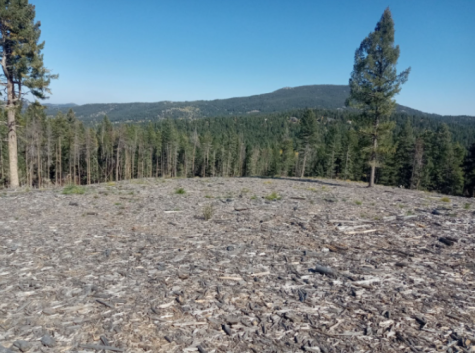
are far from the trail. Most of Flying J Trail looks as bare as
this.
(Sydney Sheets)
Flying J Trail is one of the less populated trails, however, this is fitting, because it’s definitely not one of the best trails. It has a lot of open space and seems significantly less foresty than the others and the trail had almost exclusively pine trees. However, the grass had some nice reds, browns, and different greens. The best part of the trail is the piles of wood along the edges, which gave the trail a nice firewood smell. There weren’t as many cool or big rocks, like the other trails, in fact, hikers should wear thick shoes because most of the rocks were small and sharp. This trail was unique for both its lake and informational trail signs, which talked about the park. Overall, this trail wasn’t the best for fall hiking but it wasn’t horrible.
This was a short and easy, loop trail, which only took ~30-45 minutes. Its altitude was 7500-8700 ft and the entire trail was 2.9 miles. There aren’t many loops along this trail, except a small path that gets closer to the lake. It was dog (leash required) and horse friendly and had some picnic areas near the shining, reflective lake.
Maxwell falls and Mayers Ranch were two very similar trails. Its main differences were the drop-off and the shallow stream that runs along the trail. Maxwell falls is very green but also has nice patches of color from the aspens and red bushes. This trail had a strong smell of fall leaves and a gentle sound of a flowing stream. This trail is also sewn with rocks and roots have grown into the trail which gives off a cool, natural feel. It had more large rocks near the beginning and less tree diversity as hikers get further into the trail, but its peaks have the best outlooks.
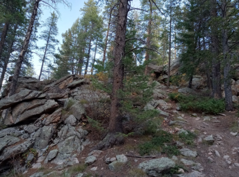
the huge rock formations along the side. These rocks make the
trail cool and fun.
(Sydney Sheets)
Maxwell falls was the longest of the three trails. It was 7800-8400 feet in altitude and 1.6-4 miles long. The upper trailhead leads to a mile round trip (follow the signs to the falls) or a 3-mile trip (after turning left down Cliff Head trail). The longest trail (4 miles) starts at the lower parking lot; it is a medium-level hike and well worth the effort. The lower Maxwell Falls trail breaks off into the cliff loop, so people can easily do a quick hike around the loop or a longer hike up the Maxwell Trail. The Maxwell Trail was a little over two hours long and Cliff Loop was roughly an hour. The trail map shows a grey and red path, but it’s unclear if the red path is a road or a trail. It’s possible, but unclear, that there are two paths. Maxwell Falls is dog-friendly (leash required) but has no picnic areas and few places to stop, off the trail.
Berrian Mountain Park may show up on google maps, as a Conifer trail, but I think this trail is inaccessible (at least by road).